Saturday, October 30, 2010

A Light At The End Of The Tunnel


This week's PhotoHunt theme is dark.
dark, humid limestone cave in Tasmania is the perfect place to look for glow-worms. 
Glow worms are not really worms, but the luminous larval stage of a fungus gnat. One can only assume that the misnomer  is due to the fact that glow-worm sounds more aesthetically pleasing than glow-larva.
Glow-worms can be found in the rainforests, caves and abandoned gold mines of Queensland, New South Wales, Victoria and Tasmania. 
The small insects do glow as a result of chemical reaction in their abdomen produces a cold blue light. 
The bioluminescent taillight is used to lure insects to the glow-worm's elaborate traps which consist of anywhere between 10 to 50 plus vertical hanging threads of silk studded with sticky droplets of mucous.
The life cycle of a glow worm involves four stages: egg, larva, pupa and adult fly.  Eggs are laid in small batches directly onto the walls of the site. Depending on the seasonal conditions at the time of egg-laying, the emergence of larvae from the eggs can take anywhere from three to six weeks to hatch. Due to the proximity of eggs laid in each small batch, cannibalism is common if there is a lack of an alternative food source for the larvae.

Friday, October 22, 2010

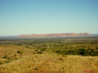
Gosses Bluff

Uluru, Kings Canyon, and Alice Springs are common destinations for visitors to Australia's Red Center. All three of these "must sees" make the distance traveled to arrive at the center of a very large continent well worth the trip. But visitors should take a few extra days for some outback exploration, because there is plenty more out there. 
I strongly recommend Gosses Bluff, a crater-like formation that measures 5 kilometers in diameter and 150 meters in height, located 175 km west of Alice Springs. It is believed that the rock-rimmed hole was created millions of years ago when a very large comet or meteorite crashed into the earth. The original scar would have measured 22 kilometers in diameter, but over time erosion reduced it to it's present day size.

For the local Western Arrernte Aboriginal People, the site is known as Tnorala, and it is a sacred place. The traditional owners of the land believe that Tnorala was formed when a group of women danced across the sky as the Milky Way. During this dance a mother put her baby to rest in its wooden baby-carrier. The carrier toppled over the edge of the dancing area, crashed to earth, and forced the rocks upward, forming the circular mountain range. The baby's parents, the evening and morning star (Venus) continue to search for their baby.
Tnorala (Gosse Bluff) is a day-use area, with picnic facilities and short walks.

Monday, October 18, 2010

Bojangles

A visit to the red center wouldn't be complete without a visit to Bojangles in Alice Springs. The historic venue first opened its doors in 1935 as a guesthouse that offered accommodation and basic hospitality. Over the years the establishment has evolved to its present iteration, a popular watering hole.
Few visitors to Alice can resist the beckoning call of the red swinging saloon doors. As patrons pass over the threshold they are transported to a distant time to find themselves surrounded by guns, boots, motorbikes, pioneering artifacts, taxidermy, bones and photos. 
Once patrons have perused the impressive collection of wild west mementos they can belly up to the bar for a coldie and some peanuts, or settle in at one of the communal tables for some distinctive outback tucker--camel, crocodile, kangaroo or emu. 

Saturday, October 16, 2010

It's a Small World...


This week's PhotoHunt theme is miniature.

If you are visiting Albuquerque, New Mexico, you may want to add the Tinkertown Museum to your list of must visits. Located on the Turquoise Trail, behind glass bottle and cement walls, the 22 room maze-like museum houses one of the more impressive miniature collections out there. The magical animated miniature world  includes scenes from the circus and the wild west. In addition to the inhabitants of the new frontier and the characters found under the big top, the museum is home to an eclectic collection of Americana. 
The eccentric collection is the the result of wood carver Ross Ward's vision; he carved and built his miniature folk art museum for over 40 years. Unfortunately, the talented artist, who had Alzheimer's Disease, passed away in 2002.  However, his legacy continues as each year thousands of visitors visit his impressive collection of miniatures and all sorts of memorabilia. 

Friday, October 15, 2010

Not To Be Wasted

Petitions by Change.org|Start a Petition 


Back in my pre-teen years, we rented a house that had a concrete back yard. I'm not sure what possessed the owners to cover the earth with a man-made material, but it sure made yard clean-up easy. There was no drama of who was going to mow the lawn or pull the weeds. Of course, the conquering of mother nature had its downside and her revenge came during high summer when the New Mexican sun raised the back yard temperatures to what could only be comparable to hell. Fortunately, the overwhelming heat could be supressed by dragging out the hose and spraying down the concrete jungle. At the time the water rushing across the sealed ground, down the driveway and into the gutter was a symbol of relief. Today, as I reflect on that image, I can only shake my head in disbelief and wonder how we could have been so wasteful of something so important. It isn't as if we lived in an area with an abundance of water; in fact, we were right smack in the middle of the desert.
Fortunately, by the start of the new millennium we began to respect the world's most precious resource and the local government began to educate its citizens about the necessity of water conservation. In just over a decade the way water is used in the city has drastically changed and water conservation has become an integral part of life.  People have become aware of their personal water use. Older toilets and washing machines are being replaced by lower water use models. Areas of large green grass have been replaced with native, drought tolerant vegetation. Sprinklers have been replaced with drip irrigation systems or, where  necessary, are only used on specific days during the early morning or late evening.
Of course these changes took time and there are still those that are resistant to change, but as the population continues to be educated about water conservation, the limited resource will receive the respect it deserves.
As I look to the future, I can only hope that my current hometown in Southern Australia  will soon begin to educate its population about the necessity of water conservation. It is not uncommon to hear the locals boast about how we live in the driest state in the driest continent. This may be true, but many still want to have lush green lawns, and they want the freedom to use the hose to wash their cars and sidewalks. During the last two summers, the water restrictions that have been imposed--due to low reservoir levels from the current drought--have been met with resistance. If the fact that we live in an area effected by extreme drought is not enough to gain the support of those opposed to enforced water conservation measures, perhaps it is time for the government to turn to educating the population. How else can  we are  ensure ample water for future generations?

Today October 15th 2010 is Blog Action Day, its theme, water. You can read more about this event here blogactionday.change.org.

Thursday, October 14, 2010

Wanyu Ulurunya tatintja wiyangku watima

Most visitors to Uluru are happy with a photo in front of the picturesque rock. However, there are those who arrive at this World Heritage site with the goal of conquering Mother Nature by climbing to the tip of the monolith. 
To bag the peak, trekers must follow the traditional route that is a Dreamtime track--a pathway used by the spiritual ancestors of the Anangu people. The route holds spiritual significance and it is for that reason that the Aboriginal owners ask visitors not to climb the Uluru. It is not illegal to climb the sandstone formation, and many people, ignoring the traditional owners' plea, make their way to the top anyway. 
Prior to my visit to Uluru I was unclear of why the traditional owners didn't just prohibit the climb. I have since learned that even though the land was returned to the Anangu in 1985, they have since leased the land back to the government for 99 years. The lease included a promise that climbing Uluru would be banned; however, the climb remains open. Each year tens of thousands of people make the ascent. Unfortunately, over 35 people have died making the dangerous climb.
When visiting Uluru, I found the legality of climbing Uluru irrelevant. Even though I am an avid peak bagger I felt that my respect for the local culture easily outweighed my desire to climb the monolith. 

Wednesday, October 13, 2010

Tip Of The Monolith

Most people would probably be stumped if asked to give an example of a monolith. However, show a picture of Uluru rock and most people can easily identify one of Australia's most most famous landforms.  Of course, most Piranpa (non-Aboriginal people) will refer to the famous image as Ayers Rock, but the Anangu (Aboriginal people of the western desert) prefer that the spiritual landform is called by its native name Uluru.

Each year almost a half a million visitors make the long journey to the center of Australia to visit Uluru. Most visitors have seen pictures of the majestic, rich red sandstone mound change colors during sunrise and or sunset and they come to watch and photograph Mother Nature's light show in person. However, no matter how many pictures they have seen most will become overwhelmed by the spectacular event and many will leave touched in a way they never expected.

Viewing Uluru from a distance is just the tip of the monolith--literally. The 348 meter high rock actually extends several kilometers below the surface of the ground. Visitors are encouraged to become acquainted with the area walking the perimeter of the rock. The 9.4 km trail takes between 3-4 hours. As visitors make their journey around one of the greatest wonders of the world they are treated to an ever changing landscape. Similar to the shifting colors in the early morning or late evening light, each step walked brings subtle changes in the rock face--there are no two views that are the same.

Monday, October 11, 2010

You Take My Breath Away

We arrived at the trailhead just as the sun was peaking over the horizon. This time of year heat was not as great a concern as it would have been in high summer. We arrived early that cool autumn morning; not because we were trying to avoid the heat. Rather, it was the 4 hour drive that lay ahead of us that had forced the predawn wake-up. We hoped to spend at least a few hours on the trail before continuing down the road to Uluru.
As I strapped on my backpack I was relieved to have arrived so early. I knew that as the sun climbed high into the sky the solitude that we were about to be offered would quickly disappear as the throngs of day trippers arrived at Kings Canyon. Our goal was to quickly hike the 6 kilometer Rim trail, and then hopefully have some time on the Ernest Giles Trail. We needed to be on the road no later than one o’clock if we were to arrive at Uluru for the world famous sunset.
The trail quickly took us from the canyon floor up towards the rim. It didn’t take long to understand why so many refer to the 500 step climb Heart Attack Hill. Had the climb not taken our breath away the panoramic view from the top would have. In addition to an unobstructed 360° view we were also able to peek down the 270 meters to the canyon floor. We stood in silence as we contemplated how the forces of nature had etched the amazing landscape that lay before us.

As we walked the rim we became aware that the masses of humanity had arrived. Fortunately, the trail is only one way, and we were at least an hour ahead of anyone else.
In just over an hour we reached the intersection of the Rim Walk and the Earnest Giles Track. For once, time was on our side, and since we were well ahead of schedule we had a couple of hours to explore the 21 kilometer trail. As we followed the meandering path that lead away from the towering wall of the grand canyon the solitude stolen by the masses behind us soon returned and our only company was spinifex pigeons. With each step it became more and more obvious that the long distance track was not well traveled and we assumed that we had left the highlight of the park behind us. Thus, we were completely taken by surprise when the rugged canyon walls were replaced by dozens of mounds. For as far as we could see we were surrounded by the 100- meter tall, beehive-like formations. I was reminded of the structures built by the pre-Columbian cultures of the Americas and it was almost unbelievable that such landforms could be created by anything other than man. The trail gradually climbed and soon we were able to observe the landscape from a heightened vantage point. The rippling red rocks that lay before us we unlike anything I had ever seen. Once again I found myself breathless, but this time not from the climb. It was the majestic landscape that lay in front of us that took my breath away.


Sunday, October 10, 2010

King Style Accommodations

When visiting Kings Canyon in central Australia there aren't a lot of choices of places to bunk down for the night. Our visit to the area included a stay at the Kings Creek Station located 36 miles from the park. Guests at the working cattle/camel station are able to camp, or for those that don't have camping gear stay at a Safari Cabin. The permanent canvas cabins consist of a steel frame, canvas walls, and a solid floor. They don't have an en suite bathroom, but there is electricity and there is even a lockable door. Additional facilities include a shared toilet and shower block, kitchen, grassed picnic area, swimming pool and fire pit (the perfect place to share yarns after a long day of exploring).

Kings Creek Station was established in 1982 by Ian and Lyn Conway. The original land had no infrastructure and it was developed as a station to run cattle and export camels. However, over time tourism has come to have an important role on the property. Today, not only are accommodations available, but there are also helicopter flights, as well as camel and quad safaris.
The prime location, at the foot of the majestic George Gill Range, makes the 2,000 square kilometer Kings Creek Station a good place to experience the natural bush of the outback.

Saturday, October 9, 2010

What You Don't Know Could Kill You


This week's theme is stripes.
When I came across this guy taking a nap on the Eyer Peninsula I had no idea that it is the 5th most venomous snake in the world and probably the fastest of all Australian snakes when it comes to striking a victim. I also was unaware that unlike most snakes, the Death Adder will not necessarily retreat from humans. Now that I understand how dangerous a Death Adder can be, the next time I come across a snake with dark brown and black stripes I will be more cautious.
The Common Death Adders, which can reach 100 centimeters in length, are found over much of eastern and coastal southern Australia. Their natural habitat includes forest, woodlands, grasslands and heathlands. Due to its band stripes, it is a master of camouflage and can easily hide underneath leaf litter and debris. 

Thursday, October 7, 2010

These Taters Are The Bomb

 
I can't say that I enjoyed the show MasterChef USA--I didn't make it past the first episode. However, MasterChef Australia is a whole different story and I have watched every episode of the past two seasons. In season 2 during a showdown Celebrity chef Frank Camorra and contestant Marrion had to make Bombas. As I watched the contestants go neck and neck making the Spanish potato croquettes-- with a surprise filling--I knew what we would be having for dinner the next night.

Bombas (adapted from MasterChef)

Ingredients:

2 large desiree or waxy red potatoes
1 tablespoon olive oil
salt
pepper
12 inch cubes Spanish chorizo
1 cup flour
2 eggs
1 cup panko breadcrumbs
1 tablespoon Spanish paprika
Vegetable oil for deep frying

Method:

Quarter the potatoes and boil them until soft. Remove skin and using the back of a spoon push through a fine sieve. Add olive oil, and season with salt and pepper to taste. Set aside.
Heat 1 tablespoon olive oil in frying pan. Fry chorizo until golden brown. Drain on paper towel and allow to cool.
Roll the potato mixture into 12 2-inch balls. With your pinky make a small hole half way into each potato ball and slide in a piece of cooled chorizo. Close the potato mixture around the chorizo and smooth into a ball.
Place flour and bread crumbs on two small plates. Add paprika to bread crumbs and season with salt and pepper to taste.  In a small bowl use a fork to mix the eggs. Toss the potato balls in the flour, dip into the egg mixture, and coat well with panko mixture. Refrigerate the coated balls until ready to cook.
Deep fry the bombas until golden brown in vegetable oil that has been preheated to 170°C (340°F).

I served them with a spicy tomato sauce.

Wednesday, October 6, 2010

A Canyon Fit For A King

Our first visit to the Red Center was back in April of 2009. Our first stop was Kings Canyon which is part of the mighty George Gill Range and is located in Watarrka National Park,  323 km southwest of Alice Springs. The drive though the desolate, isolated bush took us over 4 hours, but it didn't take too long for us to understand why the area is called the Red Center--it is as though the the ruthless sun has burned the surrounding landscape to a deep red crust.

For many, the highlight of the park is the 6 km Kings Canyon Rim walk, where hikers are treated to rugged rocky sandstone formations. After an initial steep climb hikers follow a flat path along the rim of the canyon. The trail showcases the weathered sandstone walls of the magnificent 270 meter chasm. The trail eventually descends to the canyon floor where hikers enter "The Garden of Eden." The permanent natural spring water hole is an oasis in the desert, and it is here that hikers can take a respite among gum trees and prehistoric ferns.
The trail then leads hikers back out of the canyon and along the opposite canyon rim where once again visitors are treated to a panoramic view of their surroundings and are able to appreciate the contrast of the arid land and the lush valley  before returning to the car park.

Tuesday, October 5, 2010

Out Of Sight Not Out Of Mind

Over the past few weeks I have found it a bit hard to write about Australia. It isn't that I have run out of thing to say, but for some reason I seem to lack motivation. Perhaps it is because I am currently on the other side of the world and feel detached from a place that I have come to consider my home. Last night while watching "The Alice", I was transported to deep in the outback. 
The film is set in the central outback town of Alice Springs. The plot is based on an approaching solar eclipse which can be best observed from the isolated Northern Territory. Characters from all walks of life and from different parts of the world make their journey to the bush for a once in a lifetime experience. 
Overall I found the story line a bit corny, but portrayal of life in the Australian bush and the mesmerizing scenery and landscape brought  to my attention that, even though I may be separated by distance, there are still many stories to be told and pictures to be painted.

Sunday, October 3, 2010

Stopping For A Desert Pea

One of the most stunning wildflowers of the Australian bush has to be the Sturt's Desert Pea. The blood-red flowers, with their black centers, add a distinctive flair to the arid terrain in which they grow. The plant is naturally found in all states, except Victoria.
Specimen's of Sturt's Desert pee were first collect by explorer William Dampier in 1699. Today these specimens are housed at the Fielding-Druce Herbarium at Oxford University in England. The plant's common name honors Charles Sturt, who recorded seeing large quantities of the flowers while exploring central Australia in 1884. 
The flower achieved ionic status when it was adopted as the floral emblem of South Australia in 1961.

Saturday, October 2, 2010

ABC


This week's PhotoHunt theme is letters.


If it weren't for the "letters" on the signpost you could possibly miss ABC Bay. The bay is part of Lake Eyer--a huge salt lake in the center of Australia. The lake occasionally fills with water, though it has only filled to its full capacity three or four times within the last 150 years. The lake is the lowest point on the continent and it is approximately 15 meters below sea level.  To arrive at ABC Bay travelers must travel hundreds of kilometers on remote, unsealed roads. The last 60 kilometers are extremely rugged, and only traversable by 4wd.